
“Oleander is More than a Flower: Twenty-Five Years of Oceanography Aboard a Merchant Vessel.”
This retrospective article was published in Oceanography in 2019 and contains descriptions of the Oleander Program, its basic findings, and a “Peek at the Future.” Open access link here
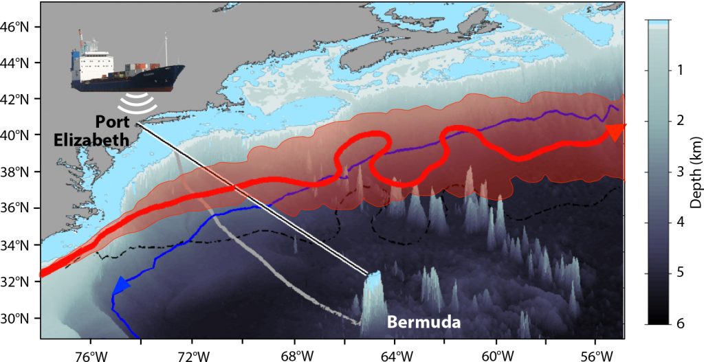
Oleander transect between Port Elizabeth, New Jersey, and Hamilton, Bermuda (black line, with its “shadow” on the seafloor in gray. The pink shaded region represents the Gulf Stream meander envelope based on the monthly mean Gulf Stream paths from the 25 cm sea surface height contour in mapped satellite altimetry from 1993 through 2014. The red line is a representative Gulf Stream path from one of these monthly means (with its dashed black “shadow” on the seafloor). The solid blue line is the 4,000 m isobath along the slope, where the Deep Western Boundary Current is flowing in the direction opposite to that of the Gulf Stream. The region shallower than 100 m depth is shaded blue.
Citation: Rossby, T., C.N. Flagg, K. Donohue, S. Fontana, R. Curry, M. Andres, and J. Forsyth. 2019. Oleander is more than a flower: Twenty-five years of oceanography aboard a merchant vessel. Oceanography 32(3):126–137, https://doi.org/10.5670/oceanog.2019.319.
Related documents:
“Oleander Project Ushers in New Era of Research” – May 2020 Bernews article
PDF of 2016 Oleander Workshop report
Oleander Project History by Dan Smith
Ship of Opportunity Program History by Robert Benway
“Packing Science into a Shipping Vessel” article in EOS